thumbnail.png
From the dataset abstract
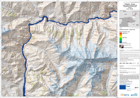
The map is showing the affected areas and the wave progression due to a lake outburst and flooded area.This is expected to follow the landslide that occured on January 4th and which is...
Source: Pakistan - Hunza: Lake Outburst Scenario Map Displaying Flooded Areas. Area 2. T+42.
Additional Information
| Field | Value |
|---|---|
| Data last updated | July 28, 2016 |
| Metadata last updated | July 28, 2016 |
| Created | July 28, 2016 |
| Format | PNG |
| License | License not specified |
| Has views | True |
| Id | 000a557f-8861-46b1-be9f-7034ce83af9e |
| On same domain | True |
| Package id | 34e5af0f-3429-4034-9886-d1cdd65f86c2 |
| Position | 3 |
| Revision id | c588b095-2290-417b-b79c-5238f093a200 |
| State | active |
| Url type | upload |