thumbnail.png
From the dataset abstract
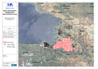
The map shows the SAR zones and the larger and smaller settlements in the area surrounding Port-au-Prince
Additional Information
| Field | Value |
|---|---|
| Data last updated | July 28, 2016 |
| Metadata last updated | July 28, 2016 |
| Created | July 28, 2016 |
| Format | PNG |
| License | License not specified |
| Has views | True |
| Id | d5118cfa-05b2-4d78-a14a-abf01d7f917a |
| On same domain | True |
| Package id | 5208e322-acb4-4029-8cc0-285ba26a2efd |
| Position | 1 |
| Revision id | e3abc9da-4595-43e6-ae41-cbbfcc249923 |
| State | active |
| Url type | upload |