thumbnail.png
From the dataset abstract
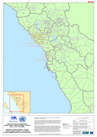
(1) This map shows where humanitarian agencies have or will distribute shelter kits at sub district level. (2) The data on these distributions is that which has been reported at nagari...
Additional Information
| Field | Value |
|---|---|
| Data last updated | July 28, 2016 |
| Metadata last updated | July 28, 2016 |
| Created | July 28, 2016 |
| Format | PNG |
| License | License not specified |
| Has views | True |
| Id | 4bcae2a9-b719-47cb-9821-d628fe28d82a |
| On same domain | True |
| Package id | cdb75d4e-534b-4191-b651-8a761d1f3514 |
| Position | 2 |
| Revision id | 421e486a-258e-4be5-8a17-4a3c260857ee |
| State | active |
| Url type | upload |