thumbnail.png
From the dataset abstract
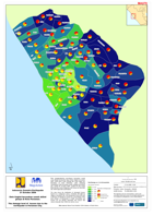
The map shows the distribution of damaged houses based on 3 categories: heavy, moderate and light by village in Pariaman City. The background shows the total of all types of damage to...
Additional Information
| Field | Value |
|---|---|
| Data last updated | July 28, 2016 |
| Metadata last updated | July 28, 2016 |
| Created | July 28, 2016 |
| Format | PNG |
| License | License not specified |
| Has views | True |
| Id | 9cab09fe-22d5-4174-a68b-2aa7a85914e5 |
| On same domain | True |
| Package id | 39d809af-527f-4b91-bae5-fc044edce6e5 |
| Position | 1 |
| Revision id | f756ccbe-3be8-483d-8159-d7a534c3f6d9 |
| State | active |
| Url type | upload |