thumbnail.png
From the dataset abstract
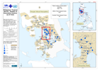
Map shows the number of Evacuation Centres (as 01 Oct), by City or Municipality, as at 01 Oct 2009, assessed by NDCC. White space means "no report" and not "none affected". The hatched...
Source: Philippines: Tropical Storms - Number of Evacuation Centres (as 01 Oct)
Additional Information
| Field | Value |
|---|---|
| Data last updated | July 28, 2016 |
| Metadata last updated | July 28, 2016 |
| Created | July 28, 2016 |
| Format | PNG |
| License | License not specified |
| Has views | True |
| Id | 3ce90815-71d2-489d-8e0d-6d1569bef99d |
| On same domain | True |
| Package id | b592a2ed-ff7d-4a46-bba0-59bca68e886e |
| Position | 2 |
| Revision id | d353f774-e254-4b8c-8e80-a384c3dea952 |
| State | active |
| Url type | upload |