thumbnail.png
From the dataset abstract
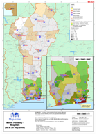
Locations of hospitals in Benin against affected areas from current flooding event and population density per km2 (2002 census). Every district hospital has one ambulance.
Additional Information
| Field | Value |
|---|---|
| Data last updated | July 28, 2016 |
| Metadata last updated | July 28, 2016 |
| Created | July 28, 2016 |
| Format | PNG |
| License | License not specified |
| Has views | True |
| Id | 0cf60cfc-443c-4a76-a703-79de35708877 |
| On same domain | True |
| Package id | f7c9ea02-9644-4a55-87a7-4a8d8eb242e8 |
| Position | 2 |
| Revision id | 90b14c54-d8ee-4611-8215-4f7b689952c3 |
| State | active |
| Url type | upload |