thumbnail.png
From the dataset abstract
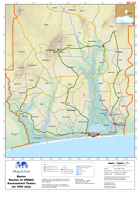
Routes of the UNDAC assessment teams showing departments and communes assessed from 15th to 19th July. These inundated areas are derived from Mapstore (Russian Topographic Mapping). This...
Source: Benin: Routes of UNDAC Assessment Teams (to 19th July)
Additional Information
| Field | Value |
|---|---|
| Data last updated | July 28, 2016 |
| Metadata last updated | July 28, 2016 |
| Created | July 28, 2016 |
| Format | PNG |
| License | License not specified |
| Has views | True |
| Id | 86e60127-8dba-43cf-a979-446d1407a33a |
| On same domain | True |
| Package id | cf627c8e-a6df-4f5d-bc25-0e927b8081e3 |
| Position | 2 |
| Revision id | 18a5c210-d6f1-4e48-b59c-9d9944913698 |
| State | active |
| Url type | upload |