thumbnail.png
From the dataset abstract
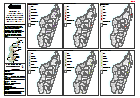
Map shows the impacts of Cyclone Enawo through 6 different indicators - affected population, number of evacuation sites, damaged houses, flooded houses, destroyed houses and houses...
Additional Information
| Field | Value |
|---|---|
| Data last updated | March 19, 2017 |
| Metadata last updated | March 19, 2017 |
| Created | March 19, 2017 |
| Format | PNG |
| License | License not specified |
| Has views | True |
| Id | bd190703-db00-42c3-9add-8b0b89089bfc |
| On same domain | True |
| Package id | 916a752d-7a5a-441c-8546-97312c5dfcbf |
| Position | 2 |
| Revision id | ac7a5a99-0d57-4c8d-822c-baba00e2a706 |
| State | active |
| Url type | upload |