thumbnail.png
From the dataset abstract
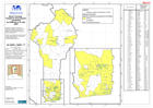
Telephone Assessments conducted by CARE up to 16th July, 2009. Map shows localities reporting various problems; Water, sanitation, infrastructure, health and food issues. In table, places...
Source: Benin: Flooding - Telephone Assessments conducted by CARE up to 16 July 2009
Additional Information
| Field | Value |
|---|---|
| Data last updated | July 28, 2016 |
| Metadata last updated | July 28, 2016 |
| Created | July 28, 2016 |
| Format | PNG |
| License | License not specified |
| Has views | True |
| Id | 83c37a98-598b-4c96-9e36-696eccc98d56 |
| On same domain | True |
| Package id | 6afb49b4-d113-4244-a290-530439272ccb |
| Position | 2 |
| Revision id | 823e8f85-cfca-4587-a8a4-9af86be32158 |
| State | active |
| Url type | upload |